Banff
Located within Alberta, Canada's Banff National Park, the resort town of Banff is one of the Great White North's major travel destinations.

Uluru National Park
Uluru-Kata Tjuta National Park, national park in the Northern Territory, Australia, in the arid center of the continent, southwest of Alice Springs. The area was established as Ayers Rock/Mount Olga National Park in 1958 and renamed Uluru National Park in 1977.

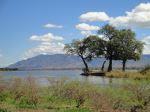
Dar Es Salaam
Dar es Salaam, Tanzania’s largest city and economic hub, offers visitors a vibrant mix of African, Arab, and European influences, making it one of East Africa’s most culturally diverse cities. With its bustling markets, lively waterfront, and historical sites, Dar es Salaam gives tourists a glimpse into the country’s rich history and dynamic present.

Seine River
The Seine River, meandering gracefully through the heart of Paris, is a living testament to the city’s rich history and vibrant culture. From the picturesque quays to the iconic landmarks lining its banks, the Seine offers an enchanting journey through Parisian elegance.

Baltimore
Baltimore's unique blend of historical significance, cultural richness, and scenic beauty makes it a must-visit destination. Whether you're exploring its museums, enjoying its waterfront, or diving into its historical roots, Baltimore offers an engaging and memorable experience.